Loading... Please wait...


- Home
- Camp, Hike & Survive
- Navigation
- Maps
- National Geographic Map - Appalachian Trail - Raven Rock to Swatara Gap


National Geographic Map - Appalachian Trail - Raven Rock to Swatara Gap

Product Description
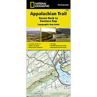
 Appalachian Trail - Raven Rock to Swatara Gap
The Raven Rock to Swatara Gap Topographic Map Guide makes a perfect traveling companion when traversing the southeastern Pennsylvania section of the Appalachian Trail (A.T.). The map follows the ridges of the Appalachian Mountains, crosses the 12-mile wide, agriculturally rich Cumberland Valley, and weaves in and out of suburbia. This section of trail, which is notoriously rocky, is rich in history with traces of early industry—charcoal furnaces, railroads, and coal mining.
Each A.T. Topographic Map Guide includes detailed topographic maps at a detail of 1 inch = 1 mile. Each page is centered on the A.T. and overlaps with the adjacent pages so there is little chance of getting lost. Along the bottom of each page is a trail profile that shows the distance between shelters, camping areas, and trail access points. The map and trail profile provide a step by step visual guide to hiking the trail, mile by rugged mile. The Topographic Map Guide is built for all levels of hiking enthusiasts, from the day tripper to the multi-month 'thru-hiker'. The front pages include resupply information, town inset maps, camping options, and much more.
Other features found on this map include: Alec Kennedy Shelter, Anna Michener Shelter, Antietam Shelter, ATC Mid-Atlantic Regional Office, Birch Run Shelter, Boiling Springs, Caledonia State Park, Clarks Ferry Shelter, Cove Mountain Shelter, Cowall Shelter, Darlington Shelter, Deer Lick Shelter, Duncannon, Ironmasters Mansion Shelter, James Fry (Tagg Run) Shelter, Lebanon, Michaux State Forest, Milesburn Shelter, Peters Mountain Shelter, Pine Grove Furnace State Park, Quarry Gap Shelter, Rausch Gap Shelter, Raven Rock, Rocky Mountain Shelter, South Mountain State Park, Susquehanna River, Swatara Gap, Swatara State Park, Toms Run Shelter, Tumbling Run Shelter.
- Waterproof and tear-resistant.
- Clearly marked trails for hiking, biking, horseback riding, ATV, and more.
- Detailed topography and clearly defined, color-coded boundaries of state parks, national recreation areas, wilderness areas, marine sanctuaries, and wildlife refuges.
- Hundreds of points of interest, including scenic viewpoints, campgrounds, boat launches, swimming areas, fishing access points, and more.
- UTM and latitude/longitude grid, as well as selected waypoints and a scale bar for easy and accurate navigation.
- Detailed road network.
- Important safety information and travel tips.
Product Reviews
Recently Viewed Items: