Loading... Please wait...
Phone: 813-785-4748


Menu
- Home
- Camp, Hike & Survive
- Navigation
- Maps
- Benton MacKaye Pocket Profile Map


Product Description
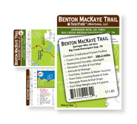
Benton MacKaye Trail with Elevation - Springer Mtn, GA to Big Creek Bridge / Davenport Gap, TN
Go2 Outfitters brings you the entire Benton MacKaye Trail at a glance on waterproof and tearproof paper. Each map weighs in at just 4.5 grams each so it won't weigh you down. This 3 map set features a Benton MacKaye Trail map on one side and elevation profile with altitudes and trail data and information on the other. Trail data information includes trail mileage, shelter locations, camp sites, water sources, resupply points, lodging, outfitters, and post offices.
This complete set covers the entire Benton MacKaye Trail from Springer Mtn, GA to Big Creek Bridge / Davenport Gap, TN.
A serious tool for trail use and hike planning.
- Waterproof, Durable and Ultralight
- Contains Elevation Profile and Trail Map
- Trail Map Includes: trail data, shelters & water sources, town data, crossing roads & trails, resupply points and mail drops
- Each map weighs only 4.5 grams, the entire set weighs less than 2 oz.
- Each Map is 3.9" x 17"
Product Reviews
Recently Viewed Items: